Randonnée Marche La Réorthe - La Rheorthe - Photo
 reva17
reva17

Utilisateur

© OpenStreetMap contributors
Longueur
Longueur
8,1 km
Altitude max
Altitude max
103 m
Dénivelé positif
Dénivelé positif
147 m
Km-Effort
Km-Effort  
10,1 km
Altitude min
Altitude min
31 m
Dénivelé négatif
Dénivelé négatif
147 m
Boucle
Boucle
Oui
Date de création :
2014-12-10 00:00:00.0
Dernière modification :
2014-12-10 00:00:00.0

(0 Avis)

Marche
Marche
2h11
Difficulté : Moyen

Scannez ce code QR pour ouvrir la randonnée dans l'application SityTrail

Application GPS de randonnée GRATUITE

Logo SityTrail SityTrail

IGN / Instituts géographiques

Télécharger SityTrail sur l'App Store Télécharger SityTrail sur Google Play

Logo SityTrail SityTrail World

Le monde est à vous

Télécharger SityTrail sur l'App Store Télécharger SityTrail sur Google Play Télécharger SityTrail sur Huawei AppGallery

À propos

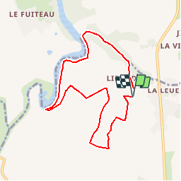
Randonnée Marche de 8,1 km à découvrir à Pays de la Loire, Vendée, La Réorthe. Cette randonnée est proposée par reva17.

Description

Retenue de l'Angle Guignard Coteaux et vallons -Quelques passages difficiles

Profil altimétrique

Localisation

Pays :
France
Région :
Pays de la Loire
Département/Province :
Vendée
Commune :
La Réorthe
Localité :
Unknown
Départ:(Dec)
Départ:(UTM)
649418 ; 5166250 (30T) N.

Randonnées à proximité

Randonnée Marche La Réorthe - Ma Réorthon 2017 - Photo
Marche
cath310

Marche

Moyen
La Réorthe, Pays de la Loire, Vendée, France
25 km | 30 km-effort
6h 25min
Oui
Randonnée Marche Bournezeau - St-Vi cent Puymaufrais  - Photo
Marche
reva17

Marche

Très facile
Bournezeau, Pays de la Loire, Vendée, France
9,8 km | 12 km-effort
2h 37min
Oui
Randonnée Marche Bournezeau - St Vincent Puymaufrais - Photo
Marche
reva17

Marche

Facile
Bournezeau, Pays de la Loire, Vendée, France
8,6 km | 10,5 km-effort
2h 19min
Oui
Randonnée V.T.T. La Réorthe - La Réorthe Scillé - Photo
V.T.T.
tracegps

V.T.T.

Très difficile
La Réorthe, Pays de la Loire, Vendée, France
87 km | 105 km-effort
6h 0min
Non
Randonnée V.T.T. Chantonnay - Vendée Verte 2005 - Photo
V.T.T.
tracegps

V.T.T.

Très difficile
Chantonnay, Pays de la Loire, Vendée, France
56 km | 70 km-effort
4h 30min
Oui
Randonnée V.T.C. Sainte-Hermine - grand bateau  - Photo
V.T.C.
gcagne

V.T.C.

Facile
Sainte-Hermine, Pays de la Loire, Vendée, France
12 km | 14 km-effort
1h 32min
Non
Randonnée Marche Chantonnay - Le charpre-vallee Gd Lay GR364 - Photo
Marche
Sylvie SURRAULT

Marche

Très facile
Chantonnay, Pays de la Loire, Vendée, France
6,8 km | 8,3 km-effort
1h 32min
Oui


Fermer
Mes abonnements